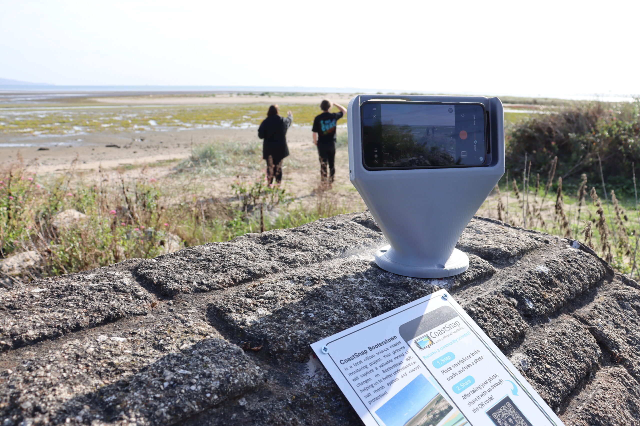

A team of scientists led by researchers from Trinity’s School of Natural Sciences launched a global citizen science project, CoastSnap, in Dublin Bay. The initiative, launched in September, invites members of the public to take photos of the coastline from fixed locations, turning everyday phone pictures into data that researchers can use to monitor coastal change over time.
First launched nine years ago in Sydney, CoastSnap started as a community beach monitoring project. Since then, it has gone global: today, there are more than 650 CoastSnap stations worldwide, which indicates it has proven to be a very successful citizen science project in terms of coastal monitoring. Officially, Ireland joined the number of countries that introduced CoastSnap this autumn, following the installation of one station in Dublin Bay. While there were already a few CoastSnap stations across Ireland, no one reached out to officially add the initiatives as regional projects to the CoastSnap website, so Ireland was only officially enlisted recently.
At its core, CoastSnap is accessible. Creating the station itself is very cheap: the only expenses come from 3D printing the holders, and in some cases purchasing fitting, railings, or a post. This totals under €50. The installation itself does not require much time either: it could be done in around twenty minutes.

The project is incredibly user-friendly — anyone with a phone (including children) can contribute by taking a snap. Involving citizens in this job is profoundly helpful to researchers: without the contribution of the public, it is hard to have environments monitored so frequently. Some locations are located too far away, and checking them several times per day would get too expensive with travel, so engaging civilians saves both time and money while at the same time gives citizens an opportunity to meaningfully support environmental research.
CoastSnap can be viewed loosely as a photogrammetry project as well. Photogrammetry is a relatively novel method of environmental monitoring in the fields of natural science, among others. It involves overlaying a series of 2D photographs — normal photogrammetry also involves the creation of 3D models from these, but this is not included here — to efficiently note landscape changes with accurate measurements and dimensions from georeferenced points of interest.
To achieve this image accuracy, photographs need uniformity. Dr Krueger notes that the majority of photos submitted were perfect, but one or two were too zoomed in and blurry. Krueger recalls a particular photo which features a gorgeous sunset she would love to have as a screensaver, but notes that the sun’s rays made the photo unusable from a data standpoint. What helps to achieve photography consistency, however, is the station’s already predetermined angle for inserting the phone. The location also features two easily identifiable landmarks — one closer and one further away — to georeference the photos to match aspect and ratio.
The funding for CoastSnap Dublin Bay was awarded in December 2024 by the Trinity College Dublin Civic Engagement for Societal Impact Awards to Dr Erica Terese Krueger, marine scientist and postdoctoral research fellow in the Trinity Coastal Research Group. The installation of a CoastSnap station in Dublin Bay was also supported by the EU-funded REWRITE project — an international initiative that aims to revitalise Europe’s intertidal areas through “revildering”, a nature-driven approach to restoring and preserving natural ecosystems. Dr Erica Krueger takes part in this project through her research in Dublin Bay, investigating the ecological and social functioning of intertidal seascapes and assessing how factors such as sea level rise, extreme events, and biodiversity loss impact coastal environments on local and global scales.
The installation of the first CoastSnap station at Booterstown Spit was a careful decision that involved considering the concerns of local citizens. Booterstown Spit which started forming two decades ago is a naturally developing sand spit in Dublin Bay that provides the surrounding area — especially the DART line — with protection against coastal erosion, destructive wave power and flooding. The growth of this spit is still uncertain, but it is predicted to build northwards. Accordingly, this dynamic area is of immense interest to citizens and researchers alike.
Dr Krueger is already very pleased with the results that CoastSnap has revealed. The project was deployed at Booterstown Spit on September 11th, and at the time of writing, 21 photographs have been submitted (at least one every day). The photos display tide and seasonal changes. In particular, Dr Krueger notes that the salt marsh in the area has begun to die off. Having time-stamped photos means that these vital changes can be pinpointed to different dates.
All the data is public, which means that anyone can go on the CoastSnap website and look at any of the images that have been uploaded. Dr Krueger shares that this data could be used to facilitate undergraduate and master’s research projects: for instance, students could take the data, put it into Geographic Information System (GIS) software and georeference it, which would make it suitable for their research. In addition, there is a lot of untapped potential to introduce CoastSnap into primary or secondary school classes, and Dr Krueger believes it’s just a matter of time — getting in touch with educational institutions is one of her future plans.
There were not too many challenges for Dr Krueger to note. One thing that stood out, however, was the long approval process. While it could take about 20 minutes to install a station, getting the approval from local authorities took one and a half years. It is likely that the project had to undergo strict rule and regulation checks because of Booterstown’s classification as a Biosphere Reserve area. Thus, most challenges were prior to installation. For now and into the future, Dr Krueger says that the only real limitation could be the need for people. There is the risk that the project’s novelty will wear off eventually and fewer photos will be submitted. However, Dr Krueger is positive that the project will continue to be successful, taking other CoastSnap locations across the globe as examples. Engagement can be spurred by collaborating with local schools or organisations such as Tidy Towns, or just simply by showing the public that their photos are making a difference.
When discussing project goals for the future, Dr Krueger says she hopes to see CoastSnap continue for many more years to come and be present in more locations. In a half joking/half serious manner, Krueger enthusiastically says she wants them “everywhere”! In the near future, two more CoastSnap stations are to be installed in October; one at the north end of North Bull Island and one at the south. Other areas of interest include Portrane and Wexford for their intensive erosion. Krueger also explains that projects such as CoastSnap have the potential to expand into other non-coastal environmental monitoring projects. Ideas that Krueger suggested are peat bog monitoring, urban river systems, and post-storm impacts.
Projects like CoastSnap prove that contributing to environmental research is incredibly accessible and affordable — and you don’t need to be a scientist to participate! So, why not use your support for conservation science as an excuse to escape the city for a couple of hours next weekend? Explore spectacular cliffs, snap a photo at the CoastSnap station, and turn a miraculous day by the sea into a meaningful contribution to coastal research.